Refine your search
Estimate
Category
Creator / Brand
- Emanuel Bowen (11)
- Thomas Bowen (8)
- John Speed (7)
- James Gillray (6)
- Greenvile Collins (5)
- Thomas Kitchin (5)
- Abraham Ortelius (4)
- Blaeu (4)
- Jan Jansson (4)
- Janssonius (4)
- Johannes Janssonius (4)
- John Cary (4)
- John Ogilby (4)
- Ortelius (4)
- Joan Blaeu (3)
- Robert Morden (3)
- Christopher Saxton (2)
- Gerard Mercator (2)
- Johann Baptist Homann (2)
- John Senex (2)
- Mercator (2)
- Robert Sayer (2)
- Sebastian Münster (2)
- Willem Janszoon Blaeu (2)
- Anthony Van Dyck (1)
- Bourguignon D'Anville (1)
- Charles Smith and Son (1)
- Edward Weller (1)
- English School (1)
- Georg Braun (1)
- Deutsch (1)
- Henricus Hondius (1)
- Herman Moll (1)
- James Cook (1)
- John Bowles and Son (1)
- John Seller (1)
- Lionel Edwards (1)
- Lucas Janszoon Waghenaer (1)
- Nicholas Sanson (1)
- Nicolas Sanson (1)
- Ptolemy (1)
- Rand McNally and Co (1)
- The Corporation of Trinity House (1)
- Thomas Jefferys (1)
- Thomas Moule (1)
- Thomas Rowlandson (1)
- Timothy Pont (1)
Item Type
- List
- Grid
A subscription to the Price Guide is required to view results for auctions ten days or older. Click here for more information
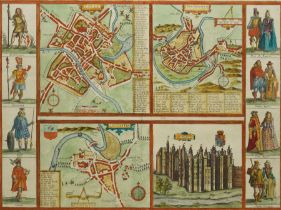

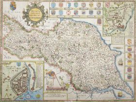
Frans Hogenberg (Flemish/German 1535-1590) and Georg Braun (German 1541-1622): 'Yorke (York) - Shrow
Frans Hogenberg (Flemish/German 1535-1590) and Georg Braun (German 1541-1622): 'Yorke (York) - Shrowesbury (Shrewsbury) - Lancaster - Richmont (Ri...
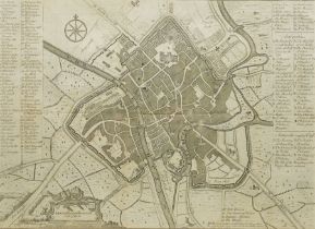
Francis Drake (British 1696-1771): 'A Plan of the City of York', 18th century engraved map 32cm x 42cm
Francis Drake (British 1696-1771): York and its Boundaries with Seals, 18th century engraved map with hand-colouring from pub. the History and Ant...
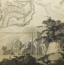
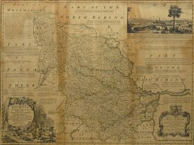
Thomas Jefferys (British c.1719-1771): 'The County of York' with inset 'Plan of Scarborough' and vie
Thomas Jefferys (British c.1719-1771): 'The County of York' with inset 'Plan of Scarborough' and view of Fountains Abbey, 18th century engraved ma...
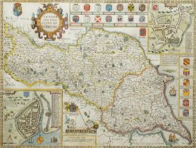
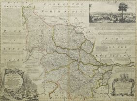
John Speed (British 1552-1629): 'The North and East Ridings of Yorkshire', 17th century engraved map with hand-colouring with inset plans of Richm...
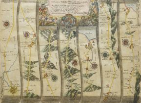
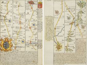
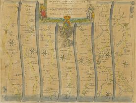
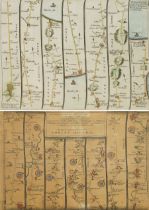
John Ogilby (British 1600-1676): 'The Roads from York to Whitby and Scarborough', late 17th century engraved strip map with hand-colouring pub. c....
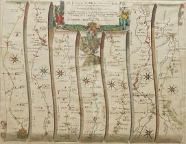
John Ogilby (British 1600-1676): 'The Road from York to West-Chester', late 17th century engraved strip map with hand-colouring pub. c.1675, 35cm ...
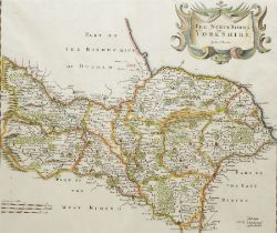
Robert Morden (British c.1650-1703): 'The North Riding of Yorkshire', 17th/18th century engraved map with hand-colouring 37cm x 42cm
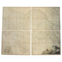
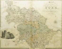
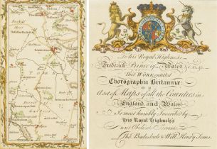
John Tuke (British 18th century): 'Map of the County of York', large engraved folding map with hand-colouring divided into 48 sections with a plan...
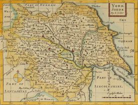
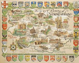
Emanuel Bowen (British 1694-1767): 'An Accurate Map of the West Riding of Yorkshire Divided into its
Emanuel Bowen (British 1694-1767): 'An Accurate Map of the West Riding of Yorkshire Divided into its Wapontakes' with a view of the City of York, ...
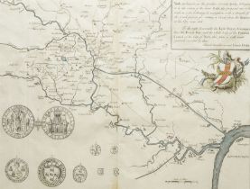
Captain Greenville (Greenvile) Collins (British 1643-1694): 'The River Humber', late 17th century engraved map or sea chart with hand-colouring sh...
Aristide Michel Perrot (French 1793-1879): Miniature County Map of Yorkshire, early 19th century engraved map with hand-colouring pub. History/At...
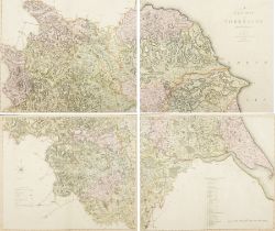
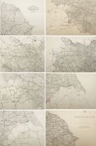
Charles Smith (British 1800-1852): 'A New Map of Yorkshire Divided into Ridings &c', complete set of four early 19th century engraved maps with ha...
John Speed (British 1552-1629): 'The North and East Riding of Yorkshire', 17th century engraved map with hand-colouring and town inset plans of Ri...
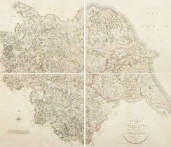
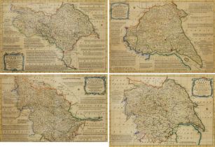
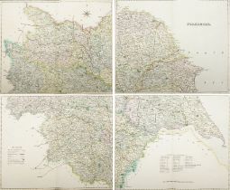
John Cary (British 1754-1835): 'A New Map of Yorkshire - Divided into its Ridings and Subdivided int
John Cary (British 1754-1835): 'A New Map of Yorkshire - Divided into its Ridings and Subdivided into its Hundreds', complete set of four early 19...
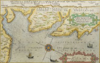
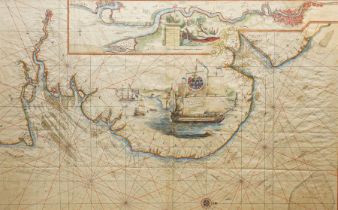
Lucas Janszoon Waghenaer (Dutch c.1534-c.1606): 'Beschrijvinghe vande Zee Custen van Engelandt'
Lucas Janszoon Waghenaer (Dutch c.1534-c.1606): 'Beschrijvinghe vande Zee Custen van Engelandt', late 16th century engraved map or sea chart with ...
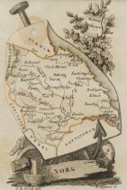
John Seller (British 1632-1697): 'Yorkshire', 18th century engraved map with hand-colouring c.1680, 13cm x 17cm
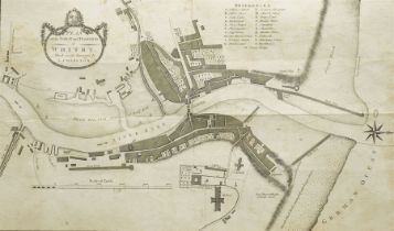
L Charlton (British 18th century): 'Plan of the Town and Harbour of Whitby', 18th century engraved map with hand-colouring pub. c.1778, 31cm x 48cm
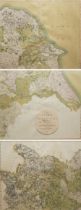
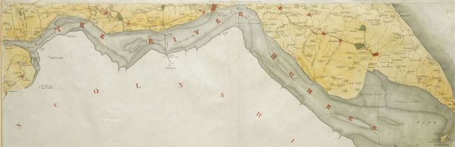
Robert Mitchell (British 18th Century): ‘Draught of the River Humber Humbly Dedicated to the Worship
Robert Mitchell (British 18th Century): ‘Draught of the River Humber Humbly Dedicated to the Worshipful Corporation of Trinity House of Kingston U...
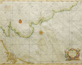
Captain Greenville (Greenvile) Collins (British 1643-1694): Sea Chart of the East Coast of England d
Captain Greenville (Greenvile) Collins (British 1643-1694): Sea Chart of the East Coast of England dedicated to Sir Ralph Delavalk, engraved 17th ...
John Cary (British 1754-1835): 'A New Map of Yorkshire - Divided into its Ridings and Subdivided int
John Cary (British 1754-1835): 'A New Map of Yorkshire - Divided into its Ridings and Subdivided into its Hundreds, set three 19th century engrave...
Richard Blome (British 1635-1705): 'Yorkshire' and 'West Riding of Yorkshire', pair 17th century engraved maps pub. c.1670, 30cm x 36cm (2)
Emanuel Bowen (British 1694-1767): 'Yorkshire Divided into its Ridings' 'North Riding of Yorkshire'
Emanuel Bowen (British 1694-1767): 'Yorkshire Divided into its Ridings' 'North Riding of Yorkshire' 'West Riding of Yorkshire' and 'East Riding of...
Captain Greenville (Greenvile) Collins (British 1643-1694): 'The River of Thames from London to the
Captain Greenville (Greenvile) Collins (British 1643-1694): 'The River of Thames from London to the Buoy of the Nore', 17th century engraved map o...
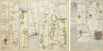
Emanuel Bowen (British 1694-1767) and John Owen (British 18th century): York to Whitby and Stamford
Emanuel Bowen (British 1694-1767) and John Owen (British 18th century): York to Whitby and Stamford to York, pair early 18th century engraved road...
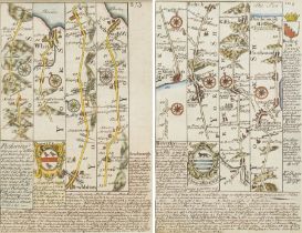
Emanuel Bowen (British 1694-1767) and John Owen (British 18th century): Pickering to Whitby and Scar
Emanuel Bowen (British 1694-1767) and John Owen (British 18th century): Pickering to Whitby and Scarborough and Kingston-Upon-Hull to Flamborough ...
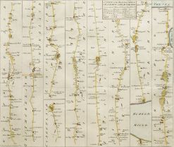
John Bowles (British 18th century): 'A Survey of the Road from London to Flamborough Head Yorkshire'
John Bowles (British 18th century): 'A Survey of the Road from London to Flamborough Head Yorkshire', scarce 18th century engraved road strip map ...
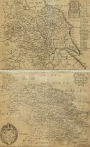
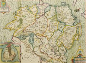
Christopher Greenwood (British 1786-1855) and John Greenwood (British 1791-1867): 'Map of the North
Christopher Greenwood (British 1786-1855) and John Greenwood (British 1791-1867): 'Map of the North Riding of the County of York', 19th century en...
Henry Teesdale (British 1776-1856): 'Yorkshire', complete set of four early 19th century engraved maps with hand-colouring pub. c.1830, 37cm x 46c...
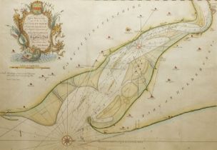
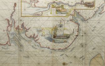
Henry Teesdale (British 1776-1856):The River Humber and Spurn Head, early 19th century engraved map with hand-colouring pub. by Henry Teesdale & C...
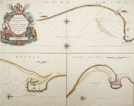
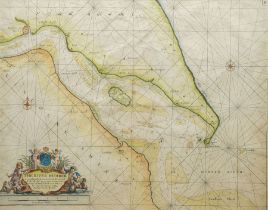
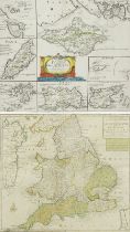
Capt. Greenvile Collins (British 1643-1694): 'Burlington Bay, Scarbrough & Hartlepoole', 17th century hand coloured engraved sea chart or map with...
Emanuel Bowen (British 1694-1767): 'An Accurate Map of the West Riding of Yorkshire Divided into its
Emanuel Bowen (British 1694-1767): 'An Accurate Map of the West Riding of Yorkshire Divided into its Wapontakes' with a view of the City of York, ...
John Ogilby (British 1600-1676): 'The Road from York to West-Chester', late 17th century engraved strip map with hand-colouring pub. c.1675, 35cm ...
Emanuel Bowen (British 1694-1767) and John Owen (British 18th century): Collection of Road Strip Map
Emanuel Bowen (British 1694-1767) and John Owen (British 18th century): Collection of Road Strip Maps including York to Knaresborough; Pontefract ...
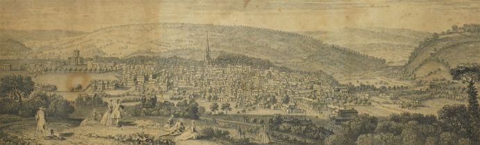
Samuel Buck (British 1696-1779) and Nathaniel Buck (British 18th century): 'The East Prospect of She
Samuel Buck (British 1696-1779) and Nathaniel Buck (British 18th century): 'The East Prospect of Sheffield in the County of York', 18th century en...
Edward Weller (British 1891-1884): 'Yorkshire', complete set of four engraved maps with hand-colouring, together with another similar set of Yorks...
John Senex (British c.1678-1740): The Road from Lincoln to Bridlington and Flamborough Head and the
John Senex (British c.1678-1740): The Road from Lincoln to Bridlington and Flamborough Head and the Road from London to Kings-Lynn in Norfolk (fra...
John Senex (British c.1678-1740): The Road from Lincoln to Bridlington and Flamborough Head
John Senex (British c.1678-1740): The Road from Lincoln to Bridlington and Flamborough Head, scarce French edition 18th century engraved road stri...
Mostyn John Armstrong (British fl.1769-1791): 'York', 18th century engraved road strip map with hand-colouring of York with Easingwold and surroun...
C Eric Simpson (British 20th century): 'The West Riding of Yorkshire' including York, original pictorial map watercolour and ink on board signed, ...
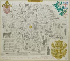
Joseph Lloyd Carr (British 1912-1994): 'Yorkshire', limited edition colour literary and pictorial historical map of Yorkshire, eighth edition numb...
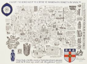
Joseph Lloyd Carr (British 1912-1994): 'Yorkshire', limited edition colour literary and pictorial historical map of Yorkshire, second edition numb...
Laurence Keeble (British 1916-2004): Sea Chart and Map of the 'Sinking of the German Battle Cruiser
Laurence Keeble (British 1916-2004): Sea Chart and Map of the 'Sinking of the German Battle Cruiser 'Scharnhorst' 26th December 1943', mixed media...
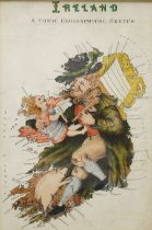
Lilian Lancaster (Tennant) (1852-1939): 'Ireland - A Comic Geographical Sketch', early 20th century lithographed caricature map of Ireland pub. Or...
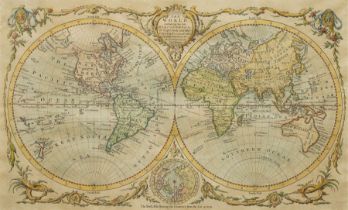
Thomas Bowen (Welsh 1733-1790): 'The World including the late Discoveries by Capt. Cook and other C
Thomas Bowen (Welsh 1733-1790): 'The World including the late Discoveries by Capt. Cook and other Circumnavigators', late 18th century engraved m...
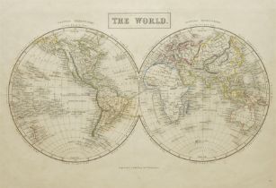
Sidney Hall (British 1788-1831): 'The World' in Hemispheres, 19th century engraved map with hand-colouring pub. 'Black’s General Atlas: A series o...
Mathais Albrecht Lotter (German 1741-1810): 'Le Grande Bretagne ou les Royaumes D'Angleterre et D'Ec
Mathais Albrecht Lotter (German 1741-1810): 'Le Grande Bretagne ou les Royaumes D'Angleterre et D'Ecosse comme aussi le Royaume D'Irlande Divisé p...
Robert Morden (British c.1650-1703): 'The Smaller Islands in the British Ocean', 17th/18th century engraved map with hand-colouring including Isle...
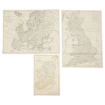
Thomas Bowen (Welsh 1733-1790): 'A New and Accurate map of Ireland' 'Great Britain' and 'Europe'
Thomas Bowen (Welsh 1733-1790): 'A New and Accurate map of Ireland' 'Great Britain' and 'Europe', set three 18th century engraved maps max 34cm x ...
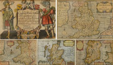
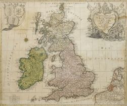
John Speed (British 1552-1629): 'England Wales Scotland and Ireland Described and Abridged'
John Speed (British 1552-1629): 'England Wales Scotland and Ireland Described and Abridged', frontispiece and set of four engraved maps with hand-...
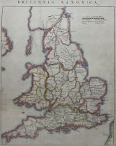
John Rapkin (British 1813-1899): Britannia Saxonica, 19th/20th century engraved map with later hand colouring originally pub. c1850, 39cm x 30cm
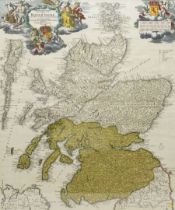
Johann Baptist Homann (German 1664-1724): 'Magnae Britanniae Pars Septenttrionalis qua Regnum Scotia
Johann Baptist Homann (German 1664-1724): 'Magnae Britanniae Pars Septenttrionalis qua Regnum Scotiae', early 18th century engraved map with hand-...
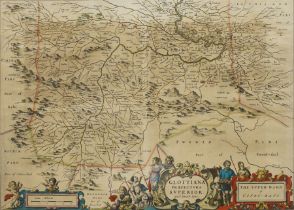
Johannes (Joan) Blaeu (Dutch 1596-1673) and Rev. Timothy Pont (Scottish c.1565-c.1615): 'Glottiana P
Johannes (Joan) Blaeu (Dutch 1596-1673) and Rev. Timothy Pont (Scottish c.1565-c.1615): 'Glottiana Praefectura Superior - The Upper Ward of Clyds-...
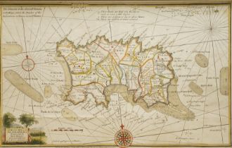
Joseph Ellis (British c.1734-c.1800) :'A Modern Map of the Island of Jersey', 18th century engraved map with hand-colouring pub. Robert Sayer c.17...
John Speed (British 1552-1629): 'The Province Ulster', 17th century engraved map with hand-colouring of Northern Ireland with inset view of Enis K...
Captain Greenville (Greenvile) Collins (British 1643-1694): 'The River of Thames from London to the
Captain Greenville (Greenvile) Collins (British 1643-1694): 'The River of Thames from London to the Buoy of the Nore', 17th century engraved map o...
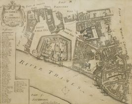
Richard Blome (British 1635-1705): 'The Tower and St Catherins (Catherine's)', 18th century engraved map or plan of the Tower of London pub. 'Stow...
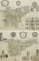
Benjamin Cole (British 1695-1766): 'Farringdon Ward' and 'Langborn Ward and Candlewick Ward'
Benjamin Cole (British 1695-1766): 'Farringdon Ward' and 'Langborn Ward and Candlewick Ward', pair 18th century engraved town maps or plans pub. M...
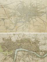
Benjamin Rees Davies (British 1789 -1872): 'Birmingham Bristol & Thames Junction Railway shewing its
Benjamin Rees Davies (British 1789 -1872): 'Birmingham Bristol & Thames Junction Railway shewing its connection with the West End of London, with ...
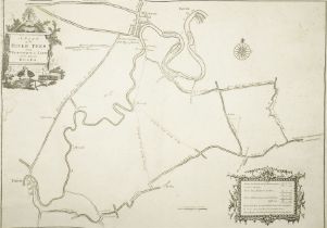
John Bell (British 18th century): 'A Plan of the River Tees from Portrack to Yarm with the Adjacent
John Bell (British 18th century): 'A Plan of the River Tees from Portrack to Yarm with the Adjacent Roads', 18th century engraved map or plan of T...