Refine your search
Sale Section
Estimate
Category
- Jewellery (260)
- Silver & Silver-plated items (131)
- Prints & Multiples (62)
- Maps (34)
- Glassware (6)
- Oil, Acrylic paintings & Mixed Media (6)
- Collectables (4)
- Watches & Watch accessories (4)
- Arms, Armour & Militaria (3)
- Writing Instruments (3)
- Books, Manuscripts & Periodicals (2)
- Ceramics (2)
- Coins (2)
- Kitchenalia (2)
- Sporting Memorabilia & Equipment (2)
- Wines & Spirits (2)
- Chinese Works of Art (1)
- Classic Cars, Motorcycles & Automobilia (1)
- Clocks (1)
- Porcelain (1)
- Toys, Models & Dolls (1)
- Vintage Fashion (1)
Creator / Brand
- Mappin & Webb (11)
- Asprey of London (4)
- Hester Bateman (4)
- Robert Morden (4)
- Tiffany & Co. (4)
- John Cary (3)
- Thomas Bradbury & Sons Ltd (3)
- William Bateman (3)
- William Comyns (3)
- William Hogarth (3)
- William Hutton & Sons (3)
- A E Jones (2)
- Adie Brothers (2)
- Blaeu (2)
- Edward Stanford (2)
- Gorham (2)
- James Dixon & Sons (2)
- James Gillray (2)
- James Wyld (2)
- Johannes Blaeu (2)
- John Speed (2)
- Mercator (2)
- Richard Crossley (2)
- Robert Lenkiewicz (2)
- Ann Bateman (1)
- Antonio Zatta (1)
- Brazil (1)
- British School (1)
- Camel (1)
- Cartier (1)
- Charles Fox (1)
- Charles Stuart Harris (1)
- Chawner & Co (1)
- Christian Dior (1)
- Christopher Saxton (1)
- Classic Car & Vehicle Brands (1)
- Continental School (1)
- Cooper Brothers (1)
- Dider Robert de Vaugondy (1)
- Disney (1)
- Ebenezer Coker (1)
- Emanuel Bowen (1)
- Georg Jensen (1)
- Gerard Mercator (1)
- German School (1)
- Glassware Makers / Brands (1)
- Henricus Hondius (1)
- Henry Wilkinson & Co (1)
- J. H. Greenock (1)
- Jacques Nicolas Bellin (1)
- Jaguar (1)
- Jodocus Hondius (1)
- John Barnard (1)
- John Bartholomew (1)
- John Langlands (1)
- John Norden (1)
- John Piper (1)
- Joshua Reynolds (1)
- L.S. Lowry (1)
- Laurence Stephen Lowry (1)
- Marino Marini (1)
- Peter Paul Rubens (1)
- Pierre Auguste Renoir (1)
- Pierre-Auguste Renoir (1)
- Ptolemy (1)
- Rembrandt (1)
- Richard Whitford (1)
- Richard Wilson (1)
- Salvador Dali (1)
- Samuel Lee (1)
- Stephen Adams (1)
- Swarovski (1)
- Thomas Gream (1)
- Thomas Rowlandson (1)
- Thomas Wallis (1)
- Van Keulen (1)
- W G Keight & Co. (1)
- WMF (Württembergische Metallwarenfabrik AG) (1)
- Waterford Crystal (1)
- William Chawner (1)
- William Eaton (1)
- William Faden (1)
Item Type
- Gemstone (196)
- Diamond (141)
- Ring (135)
- Necklaces, Pendants & Medallions (82)
- Pendant (62)
- Cutlery (41)
- Pearls (36)
- Necklace (35)
- Brooch (34)
- Map (33)
- Bracelet (27)
- Diamond Ring (25)
- Earrings (24)
- Engraving (20)
- Gold Ring (20)
- Earstud (19)
- Garnet (19)
- Dish (18)
- Etching (16)
- Opal (16)
- Ruby (16)
- Bowl (15)
- Locket (14)
- Emerald (13)
- Amethyst (12)
- Box (12)
- Baluster (11)
- Brooches (10)
- Gold Mounted (10)
- Jug (10)
- Candlestick (9)
- Cartographers and Mapmakers (9)
- Chain (9)
- Beads (8)
- Cufflinks (8)
- Fork (8)
- Salts (8)
- 15th-18th Century Art (7)
- Bangle (7)
- Cameo (7)
- Gold Pendant (7)
- Inkwell (7)
- Ladle (7)
- Pin (7)
- Condiment Set (6)
- Contemporary Art (6)
- Sugar Bowl (6)
- Teapot (6)
- Band (5)
- Cigarette Box (5)
- Eternity Ring (5)
- Modern & Impressionist Art (5)
- Salver (5)
- Stopper (5)
- Tankard (5)
- Tea Caddy (5)
- Tea Set (5)
- Bottle (4)
- Caddy Spoon (4)
- Lithograph (4)
- Plate (4)
- Road map (4)
- Screen Print (4)
- Screenprint (4)
- Silver Candlestick (4)
- Urn (4)
- Ashtray (3)
- Cake Slice (3)
- Charm (3)
- Cream Jug (3)
- Fish Server (3)
- Gold Bar (3)
- Hand Mirror (3)
- Ink (3)
- Mirror (3)
- Napkin ring (3)
- Ordnance survey map (3)
- Pin Cushion (3)
- Sauceboat (3)
- Signet Ring (3)
- Toast rack (3)
- Turquoise (3)
- Vase (3)
- Watch (3)
- Watch Accessories (3)
- Watch Chain (3)
- Wedding Ring (3)
- Wine Coaster (3)
- Cigarette case (3)
- Badge (2)
- Badges, Medals & Pins (2)
- Basket (2)
- Candelabra (2)
- Choker (2)
- Cigarette case (2)
- Cup (2)
- Decanter (2)
- Diamond Brooch (2)
- Dressing Table Set (2)
- Earclip (2)
- Jewellery Brands (2)
- Magnifying Glass (2)
- Militaria (2)
- Military badge (2)
- Military Brooch (2)
- Pen (2)
- Quaich (2)
- Road map (2)
- Scent bottle (2)
- Silver Brooch (2)
- Snuff box (2)
- Spirits (2)
- Strainer (2)
- Sugar Caster (2)
- Tazza (2)
- Tea Strainer (2)
- Tie Pin (2)
- Tray (2)
- Whisky (2)
- 19th-21st Century Art (1)
- Bangles (1)
- Bell (1)
- Card case (1)
- Ceramic Tea Set (1)
- Chinese Vase (1)
- Coffee Pot (1)
- Coffee Set (1)
- Coin (1)
- Collar (1)
- Compact (1)
- Corkscrew (1)
- Crumb Scoop (1)
- Decanter Label (1)
- Ear Studs (1)
- Egg Cup (1)
- Emerald Ring (1)
- Entrée Dish (1)
- Figure (1)
- Fob Seal (1)
- Glass Bottle (1)
- Glass Decanter (1)
- Goblet (1)
- Hat Pin (1)
- Hunting (1)
- Hunting Equipment (1)
- Inkstand (1)
- Lighter (1)
- Meat Dome (1)
- Model (1)
- Money Clip (1)
- Muffin Dish (1)
- Mug (1)
- Opal Ring (1)
- Pap Boat (1)
- Perfume Funnel (1)
- Photograph Frame (1)
- Pocket watch (1)
- Portrait (1)
- Punch Bowl (1)
- Silkscreen (1)
- Silver Model (1)
- Silver Napkin ring (1)
- Silver Ring (1)
- Silver Tankard (1)
- Sleeve (1)
- Sport (1)
- Table Lighter (1)
- Tableware (1)
- Timepiece (1)
- Toy Brand (1)
- Trophy (1)
- Vesta case (1)
- Water Jug (1)
- Wine Funnel (1)
- silver bowl (1)
- List
- Grid
A subscription to the Price Guide is required to view results for auctions ten days or older. Click here for more information
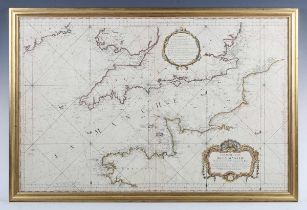

Jacques Nicolas Bellin - Carte Réduite de la Manche: map of the English Channel, sea chart showing
Jacques Nicolas Bellin - Carte Réduite de la Manche: map of the English Channel, sea chart showing the south coasts of Ireland, the British Isles ...
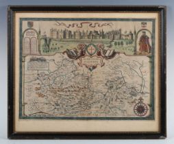
John Speed – Barkshire Described: map of the county of Berkshire, engraving with later hand colouring, 38cm x 51cm; together with Oxfordshire Desc...
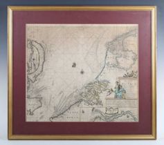
Joannes Van Keulen - A sea chart of the south part of the North-Sea extending from the Texel to
Joannes Van Keulen - A sea chart of the south part of the North-Sea extending from the Texel to the Heads, containing the coasts of Freesland, Hol...
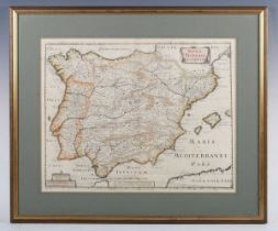
Pierre-Jean Mariette - Nova Hispaniae Descriptio: map of Spain, engraving with hand colouring,
Pierre-Jean Mariette - Nova Hispaniae Descriptio: map of Spain, engraving with hand colouring, 37cm x 47cm, within a gilt frame.
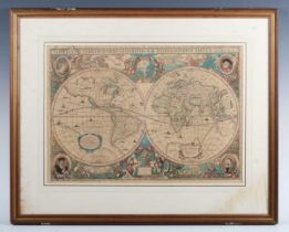
After Henricus Hondius - Nova Totius Terrarum Orbis Geographica ac Hydrographica Tabula. Auct: Henr.
After Henricus Hondius - Nova Totius Terrarum Orbis Geographica ac Hydrographica Tabula. Auct: Henr. Hondio, Amsterdam: engraved map of the world ...
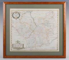
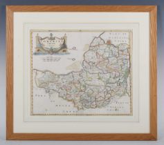
Robert Morden - Sussex; Surrey; Cumberland; Lancaster; and Surrey, a group of five maps, engravings with hand colouring, the largest 39cm x 45cm, ...
John Cary - Surry (Surrey) x2; Rutlandshire; Bedford; Northumberland; Huntingdonshire; and Huntingdonshire 1801, a group of seven maps, engravings...
John Carey – A New Map of the Circle of Swabia 1825; A New Map of the Circle of Franconia 1821;
John Carey – A New Map of the Circle of Swabia 1825; A New Map of the Circle of Franconia 1821; and A New Map of the Russian Empire 1799 (one shee...
C. Smith - A New Map of the County of Cambridge; A New Map of the County of Essex; and A New Map
C. Smith - A New Map of the County of Cambridge; A New Map of the County of Essex; and A New Map of the County of Sussex, three engravings with ha...
Robert Morden - Leicestershire; Cambridgeshire; Lincolnshire; Northamptonshire; Bedfordshire; and
Robert Morden - Leicestershire; Cambridgeshire; Lincolnshire; Northamptonshire; Bedfordshire; and Comitatus Rotelandiae tabula Nova & Aucta (Rutla...
Robert Morden - The County of Monmouth; Herefordshire; Dorsetshire; Kent; and Surrey (later smaller reprint); together with John Norden & William ...
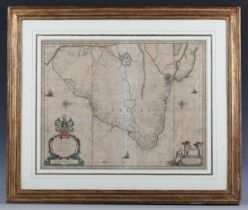
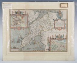
Johannes Blaeu - Brasilia: map of Brazil, engraving circa 1643 with later colour, Dutch text verso, 39cm x 49.5cm, within a gilt frame. Note: Blae...
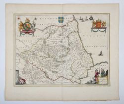
Johannes Blaeu - Episcopatus Dunelmensis Vulgo The Bishoprike of Durham: map of the county, mid-17th
Johannes Blaeu - Episcopatus Dunelmensis Vulgo The Bishoprike of Durham: map of the county, mid-17th century engraving with near period hand-colou...
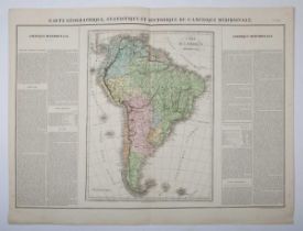
J.A. Buchon - Carte Géographique, Statistique et Historique de L'Amérique Meridionale: map of
J.A. Buchon - Carte Géographique, Statistique et Historique de L'Amérique Meridionale: map of South America with text borders, hand coloured engra...
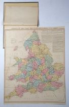
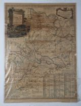
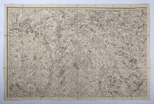
Robson & Co’s Rail Road and Map of England & Wales, with Canals, engraving with hand colouring,
Robson & Co’s Rail Road and Map of England & Wales, with Canals, engraving with hand colouring, sectionalised into eight, overall size 95cm x 72cm.
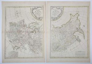
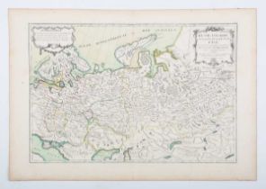
Rigobert Bonne - Partie Occidentale de L'Empire de Russie...; and Partie Orientale de L'Empire de
Rigobert Bonne - Partie Occidentale de L'Empire de Russie...; and Partie Orientale de L'Empire de Russie: maps of the Russian Empire, a pair of en...
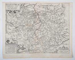
Christopher Saxton and William Kip - Lecestriae comitatus sive Leicestershyre pars olim Coritanorum:
Christopher Saxton and William Kip - Lecestriae comitatus sive Leicestershyre pars olim Coritanorum: map of Leicestershire, early 17th century eng...
Letts, Son & Co (Publishers) - London and its Environs, engraved map with hand colouring, in 36
Letts, Son & Co (Publishers) - London and its Environs, engraved map with hand colouring, in 36 sections, linen backed, 71cm x 114cm, within embos...
Mudge (Lt Col. William) - Ordnance Survey Map Sheet No. XLVII, Essex/Hertfordshire, sectionalised in
Mudge (Lt Col. William) - Ordnance Survey Map Sheet No. XLVII, Essex/Hertfordshire, sectionalised in 24 and laid on linen, published April 18th 18...
John Speed – Caernarvon both Shire and Shire-towne: map of the county of Caernarfon, engraving
John Speed – Caernarvon both Shire and Shire-towne: map of the county of Caernarfon, engraving with later hand colouring, 38cm x 51.5cm, unframed.
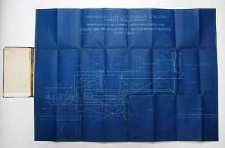
Orconera Iron Ore Company Limited (publisher) - Obregon Mines & Railway Demarcation Plan showing
Orconera Iron Ore Company Limited (publisher) - Obregon Mines & Railway Demarcation Plan showing Operations carried out between June and August 19...
James Wyld – Country round Lyme Regis 1837, folding engraved map with hand colouring in 55 sections,
James Wyld – Country round Lyme Regis 1837, folding engraved map with hand colouring in 55 sections, linen backed, 93.5cm x 126.5cm, in its case, ...
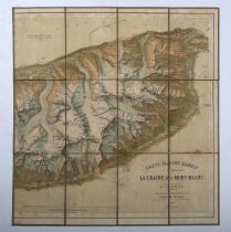
Louis Kurz – Carte Albert Barbey, La Chaine du Mont Blanc, lithographic map in twelve sections,
Louis Kurz – Carte Albert Barbey, La Chaine du Mont Blanc, lithographic map in twelve sections, backed on cloth, 56cm x 52cm, together with Henry ...
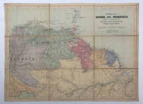
Louis Richard – Map of China The 18 Provinces, 1908, folding colour lithographic map, 64cm x 75.5cm,
Louis Richard – Map of China The 18 Provinces, 1908, folding colour lithographic map, 64cm x 75.5cm, together with Edward Stanford, Guiana & Venez...
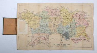
C. Le Feuvre - Map of the Island of Jersey, Divided into Parishes, with all the Roads, Lanes &c.,
C. Le Feuvre - Map of the Island of Jersey, Divided into Parishes, with all the Roads, Lanes &c., c.1900, folding map with hand coloured parishes,...
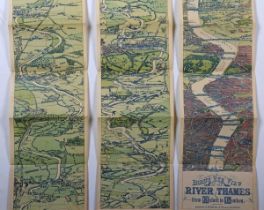
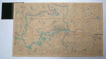
Bacon’s Bird’s-eye View of the Thames London to Oxford 1894, folding map in three parts, each
Bacon’s Bird’s-eye View of the Thames London to Oxford 1894, folding map in three parts, each folding section 143cm long, in slip case; London Cou...
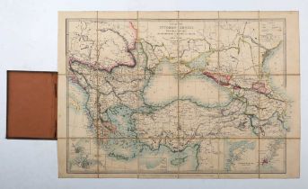
James Wyld - Ottoman Dominions: Map of the Ottoman Empire, the Black Sea and the Frontiers of Russia
James Wyld - Ottoman Dominions: Map of the Ottoman Empire, the Black Sea and the Frontiers of Russia and Persia, 18-section folding map, backed on...
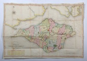
James Clarke - A Military, Marine & Topographical Survey of the Isle of Wight by James Clarke,
James Clarke - A Military, Marine & Topographical Survey of the Isle of Wight by James Clarke, Land Surveyor, Newport, 1812, engraved folding map ...
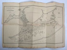
Henry Salt - A Geometrical Survey of the City of Alexandria, published 1809 by William Miller,
Henry Salt - A Geometrical Survey of the City of Alexandria, published 1809 by William Miller, engraved folding map, 59cm x 83cm.
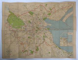
Geographia Plan of Dublin, folding map sectionalised into 36 and cloth backed, 75cm x 97cm; Bacon’
Geographia Plan of Dublin, folding map sectionalised into 36 and cloth backed, 75cm x 97cm; Bacon’s New Plan of Portsmouth, folding lithographic m...
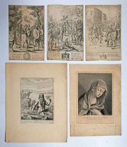
An oversize bound folio containing blank leaves, and a collection of 17th, 18th and 19th century
An oversize bound folio containing blank leaves, and a collection of 17th, 18th and 19th century etchings, engravings and mezzotints, including wo...
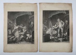
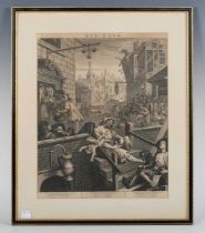
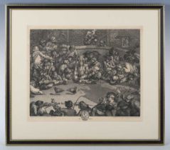
William Hogarth (1697-1764) - ‘Before’ & ‘After’, a pair of engravings, first published December
William Hogarth (1697-1764) - ‘Before’ & ‘After’, a pair of engravings, first published December 15th 1736, each 38.5cm x 31cm, unframed.
H.B.'s Political Sketches, (John Doyle), volumes I & II, published by Thomas McLean, each volume
H.B.'s Political Sketches, (John Doyle), volumes I & II, published by Thomas McLean, each volume 51.5cm x 35.5cm (2).
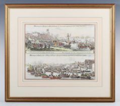
German School - 'Abbindung wie die Konigin Gross Britanien zu Portsmouth, Abbindung wie dieStadt
German School - 'Abbindung wie die Konigin Gross Britanien zu Portsmouth, Abbindung wie dieStadt London den Konig und Konigen von Hampton Court 16...
After William Hamilton - February; September, a pair of colour stipple engravings by Bartolozzi,
After William Hamilton - February; September, a pair of colour stipple engravings by Bartolozzi, oval, each 33cm x 27cm, within decorative composi...

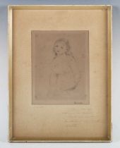
William Lionel Wyllie (British 1851-1931) - Unloading a leaky tender ship, etching, signed in pencil
William Lionel Wyllie (British 1851-1931) - Unloading a leaky tender ship, etching, signed in pencil lower left, 23cm x 35cm, within a Hogarth sty...
After Thomas Rowlandson - ‘An Excursion to Brighthelstone’: Sutton; Reigate; Crawley; Cuckfield;
After Thomas Rowlandson - ‘An Excursion to Brighthelstone’: Sutton; Reigate; Crawley; Cuckfield; Bathing Machines; Salon at the Marine Pavilion; T...
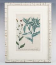
Continental School - Carduus avonaceus 309; Carduus Sphaerocephalus 314; Clematis flammula Jovis
Continental School - Carduus avonaceus 309; Carduus Sphaerocephalus 314; Clematis flammula Jovis 394; Dipsacus sativus florie rubro 467; Juniperus...
Pierre Auguste Renoir (French 1841-1919) - 'Étude pour une Baigneuse', c.1906, etching, with the
Pierre Auguste Renoir (French 1841-1919) - 'Étude pour une Baigneuse', c.1906, etching, with the artist's stamped signature, 22.5cm x 16cm, within...
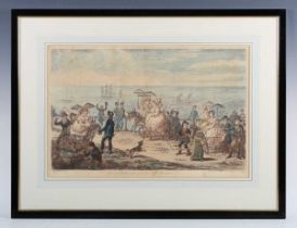
James Gillray (English, 1756-1815) - ‘'Morning Promenade upon the Cliff, Brighton', hand-coloured
James Gillray (English, 1756-1815) - ‘'Morning Promenade upon the Cliff, Brighton', hand-coloured etching, published by Hannah Humphrey, 1806, the...
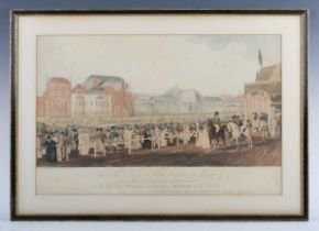
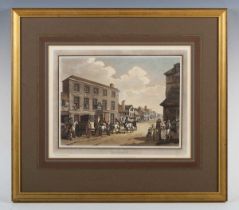
After Cracklow and Craig - View of the Pavilion and Steyne at Brighton with the promenade, 1806,
After Cracklow and Craig - View of the Pavilion and Steyne at Brighton with the promenade, 1806, depicting the Prince of Wales, his equerry, Major...
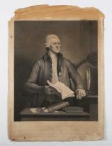
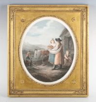
A small group of assorted prints, engravings and watercolours, including after Benjamin West, '
A small group of assorted prints, engravings and watercolours, including after Benjamin West, 'Samuel More'; a mezzotint of George Stephenson; and...
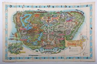
Disneyland - An original vintage 1962 Walt Disney’s Disneyland California theme park pictorial
Disneyland - An original vintage 1962 Walt Disney’s Disneyland California theme park pictorial map, printed in the USA, the map showing the variou...
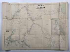
John Bartholomew’s Special Large Scale War Map of The Soudan, extending to Suakim on the Red Sea,
John Bartholomew’s Special Large Scale War Map of The Soudan, extending to Suakim on the Red Sea, 1885, folding map, 57cm x 78cm, together with Go...
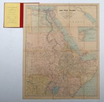
Edward Stanford - Nile Valley, folding map, sectionalised in 16 parts, backed on linen, 73.5cm x
Edward Stanford - Nile Valley, folding map, sectionalised in 16 parts, backed on linen, 73.5cm x 57cm; together with Road Map of U.A.R. Egypt Regi...
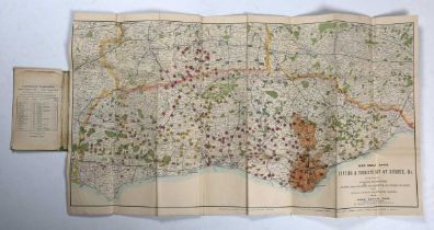
The Brighton and Sussex Hunting Map and Map of the Environs of Brighton, showing all the Roads,
The Brighton and Sussex Hunting Map and Map of the Environs of Brighton, showing all the Roads, Railways and the Meets of the Warnham Staghounds, ...
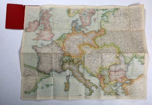
Folding maps: including Bacon’s War Map of Europe; New Orleans, Louisiana A City Map; Bacon’s New
Folding maps: including Bacon’s War Map of Europe; New Orleans, Louisiana A City Map; Bacon’s New War Map of South Central Europe; War Map No. 7, ...
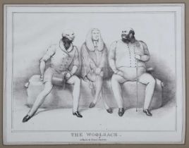
William Hogarth (British 1697-1764) - 'Gin Lane'; 'Pit Ticket', two engravings, the first 38.5cm x
William Hogarth (British 1697-1764) - 'Gin Lane'; 'Pit Ticket', two engravings, the first 38.5cm x 30cm, the second 32cm x 32.5cm, within Hogarth ...
Robert Morden - Somersetshire; Herefordshire, two engraved maps with hand colouring, the first
Robert Morden - Somersetshire; Herefordshire, two engraved maps with hand colouring, the first 36cm x 42.5cm, together with a map of Devonshire by...
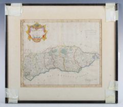
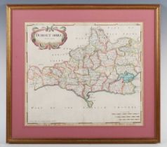
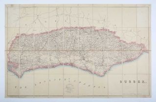
William Faden - Folding map of the County of Sussex, a reduced version of the survey by Thomas
William Faden - Folding map of the County of Sussex, a reduced version of the survey by Thomas Gream, engraving with hand colouring in twelve sect...
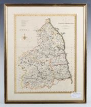
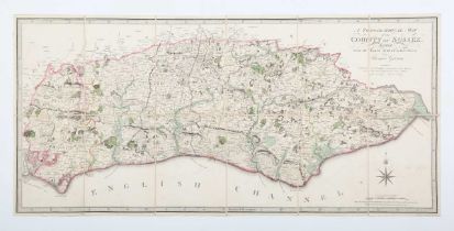
Edward Stanford – Folding Ordnance map of Sussex, engraving with hand colouring, in forty sections, linen backed, in slip case hand inscribed 'R. ...
St Janvier – Russie d’Europe avec la partie la plus peuplée de celle d’Asie, engraved map with
St Janvier – Russie d’Europe avec la partie la plus peuplée de celle d’Asie, engraved map with hand colouring, c.1771, 31.5cm x 45.5cm; together w...
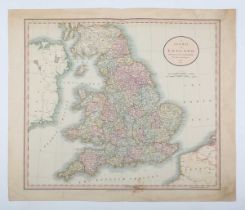
John Cary – A New Map of England, 1807, two copies, engravings with hand colouring, each plate 51.
John Cary – A New Map of England, 1807, two copies, engravings with hand colouring, each plate 51.5cm x 60cm; together with Archibald Fullarton (P...
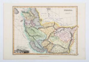
John Thomson (Publisher) - Map: Persia, engraving by Hewitt with hand colouring, 26cm x 35cm;
John Thomson (Publisher) - Map: Persia, engraving by Hewitt with hand colouring, 26cm x 35cm; together with P. Mortier, Persarum sive Parthorum Im...
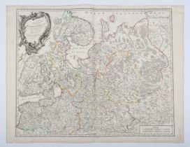
Robert de Vaugondy – Partie Septrionale de la Russie Européenne, engraving with hand colouring,
Robert de Vaugondy – Partie Septrionale de la Russie Européenne, engraving with hand colouring, 1753, 50cm x 63cm; together with John Cary, A New ...
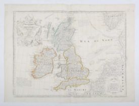
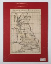
Guillaume de L’Isle – Les Isles Britanniques, engraving, published 1772, probably later restrike
Guillaume de L’Isle – Les Isles Britanniques, engraving, published 1772, probably later restrike with hand colouring, 48cm x 62cm, unframed.
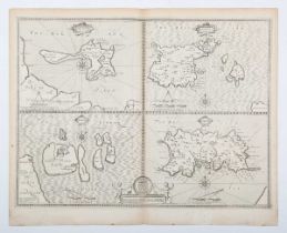
John Speed - Map of four Islands - "Holy Iland", "Garnsey" (Guernsey), "Farne" and "Jarsey" (
John Speed - Map of four Islands - "Holy Iland", "Garnsey" (Guernsey), "Farne" and "Jarsey" (Jersey)", pub. by Thomas Bassett and Richard Chiswell...
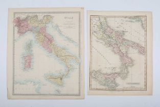
A group of six maps of Italy, comprising Royaume de Naples by M. Bonne; L’Italie by Pied de Paris;
A group of six maps of Italy, comprising Royaume de Naples by M. Bonne; L’Italie by Pied de Paris; Carte pour l’Expedition d’Annibal n Italie, de ...
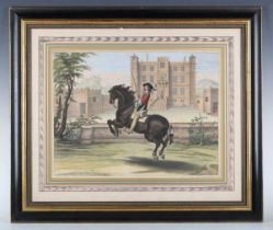
After Abraham van Diepenbeke - 'Monsigneur le Marquis a Cheval', engraving by P. Clouwet with hand
After Abraham van Diepenbeke - 'Monsigneur le Marquis a Cheval', engraving by P. Clouwet with hand colouring, 39cm x 53cm; together with a pair of...
William Hogarth (British 1697-1764) – 'Pit Ticket', engraving, originally published 1759, 32cm x
William Hogarth (British 1697-1764) – 'Pit Ticket', engraving, originally published 1759, 32cm x 38.5cm, within a Hogarth frame.