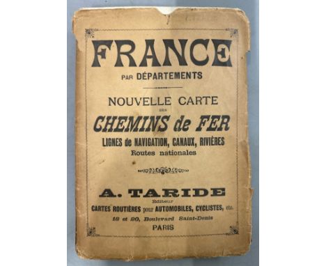
We found 120507 price guide item(s) matching your search
There are 120507 lots that match your search criteria. Subscribe now to get instant access to the full price guide service.
Click here to subscribe- List
- Grid
-
120507 item(s)/page

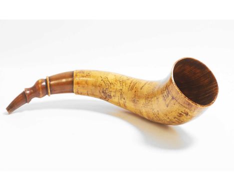
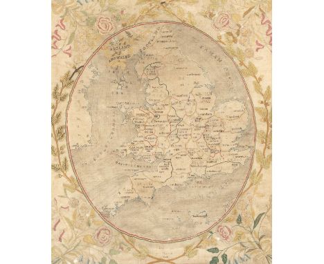
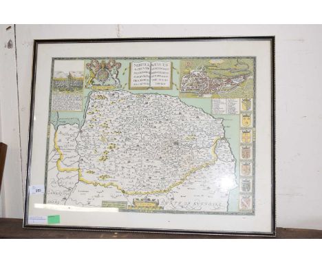
Lot 297
An American colonial powder horn, c.1760, depicting an engraved colonial map of Albany relating to the French and Indian War, inscribed 'Map of the county of Albany don by a scale eight mile to a inch 1760',35cm longCondition ReportWith smalls cracks, marks and scratches throughout commensurate with use. Small frits to the mouth piece. No major damage. The small cracks are stable.
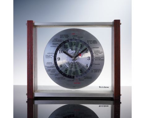
Lot 325
This Verichron world time desk clock features a brushed metal dial with a global map at its center and a rotating 24-hour ring encircled by international cities. Designed for function and flair, it displays both local time and simultaneous reference to major global time zones. The glass front and back are framed by dark-stained wood and brushed aluminum sides, offering a sleek, modernist silhouette. The quartz movement is battery-operated, marked Japan, and visible through the clear casing. A distinctive blend of utility and retro-futuristic design. Measures approximately 9.5"L x 7.75"H.Dimensions: See DescriptionCondition: Age related wear. Functionality not guaranteed.
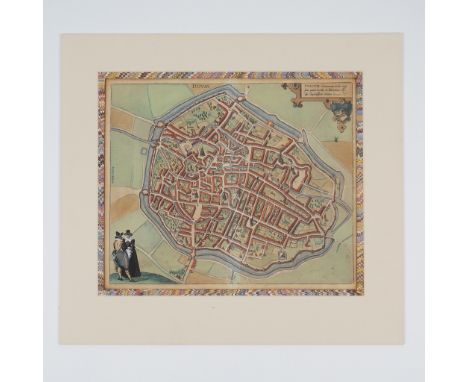
Lot 158
A beautifully detailed and hand-colored engraved map of Douai (Dovay), a historic city in northern France, from the seminal 16th-century cartographic work Civitates Orbis Terrarum by Georg Braun and Frans Hogenberg. This city view showcases the intricate layout of Douai, including its fortified walls, canals, and notable architectural landmarks. The map is bordered with vivid marbled paper and professionally matted, enhancing its aesthetic appeal. The upper corner features Latin text describing Douai as elegantly adorned and praising the city for its residents and intellectual life, underscoring its prominence during the Renaissance. An exquisite example of early urban cartography, the map captures the essence of Douai's historical importance as a center of learning and culture. The figures in period attire at the lower left and the windmill on the outskirts add a dynamic and humanized perspective, characteristic of Braun & Hogenberg's work. This map is a testament to the artistry and technical skill of the era, merging aesthetics and information in a harmonious composition. Georg Braun (1541-1622) and Frans Hogenberg (1535-1590) were pioneers of Renaissance cartography. Their monumental work, Civitates Orbis Terrarum, published between 1572 and 1617, consisted of six volumes depicting over 500 city plans and views, providing a comprehensive visual account of urban centers across Europe and beyond. This collaboration marked a significant advancement in geographical representation, blending artistry with geographic precision. Douai, historically part of the Spanish Netherlands during the time of this map's creation, was renowned for its University of Douai, founded in 1562, which contributed to the city's intellectual reputation. The city played a vital role in the region's political and cultural history, which is reflected in the meticulous detail of this map. German text on verso. Artwork can be unframed and rolled for shipment. Map without mat: 20.75"L x 16"H.Artist: Georg Braun (1541-1622) & Frans Hogenberg (1535-1590)Issued: c. 1582Dimensions: See DescriptionCountry of Origin: BelgiumCondition: Age related wear.
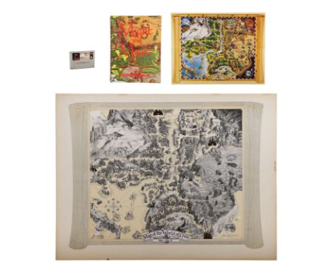
Lot 283
SUPER NINTENDO: MIGHT AND MAGIC II - Preliminary Map of the World Cron Sketch, Signed Guidebook, Poster and Game Cartridge - A preliminary map of the World Cron sketch, a signed guidebook, a poster and a game cartridge from the production of the role-playing video game Might and Magic II: Gates to Another World.The map was created by US illustrator Jim Krogle, who was also employed to draw the maps for the first instalment, Might and Magic: Book One - Secret of the Inner Sanctum. The sketch is rendered in pencil on velum and embellished with adhered printed cutouts. Krogle has signed the map in the bottom right corner in pencil.The guidebook is addressed to Krogle and signed by the game's designers, Jon Van Caneghem and Michaela Van Caneghem. Krogle has also signed the same page of the guidebook.The Might and Magic II cartridge is for the Super Nintendo Entertainment System. The poster is a printed colour version of the map. Dimensions: 103 cm x 79 cm x 0.5 cm (40.5" x 31" x 0.25")Sold without copyright; see copyright notice in the Buyer's Guide.VAT Status: M
Lot 16
PAOLO PASOTTO(Bologna 1930 - 2015)Senza titolo, 2003Olio su tela applicato su tavola di legno cm 56x57Firma e datazione al fronteSul retro dell'opera è presente la targhetta adesiva con relativo numero di archvio dell'opera(2000P5345) con firma autografa del PresidenteBibliografia: Pubblicazione sul catalogo ragionato I Tomo, Pag. 361Esposizioni: - Map-Museo Agro Pontino, Pontinia, 2016- Museo Civico Latina, 2017-2018Opera in cornice
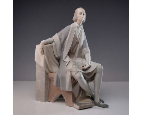
Lot 213
Matte finish porcelain bookend depicting the famed explorer seated with a map draped across his lap. Executed in soft tones of ivory, grey, and pale rose, the sculpture captures a contemplative moment in the historic navigator's journey. Lladro impressed backstamp. Artist: Salvador FurioIssued: 1969 - 1975Dimensions: 10"L x 6"W x 13"HCountry of Origin: SpainCondition: Age related wear.
![[Syria & Lebanon] Syrie & Liban, Bureau Topographique des Troupes Francaises en Levant, 1938, line backed folding map](https://cdn.globalauctionplatform.com/ec38d83d-0f06-4aa2-b067-b2e400ec9dbd/c201f26e-a9c6-4afd-8bff-b3050178a0d5/468x382.jpg)
Lot 571
[Syria & Lebanon] Syrie & Liban, Bureau Topographique des Troupes Francaises en Levant, 1938, line backed folding map with retailer label for Edward Stanford Ltd and handwritten title 'Syria', 82cm x 118cm (21cm x 17cm folded)Centre of folder map a little damp stained. Some spotting to map. Stamped to lower right corner and pasted label for Edward Stanford. Cut with irregular margins. Title label a little soiled.
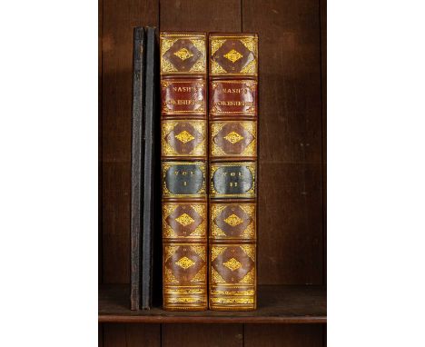
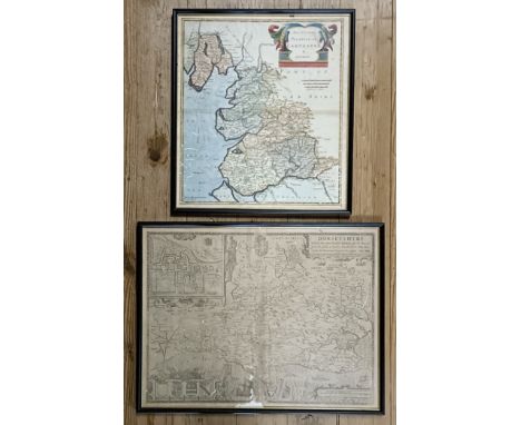
Lot 608
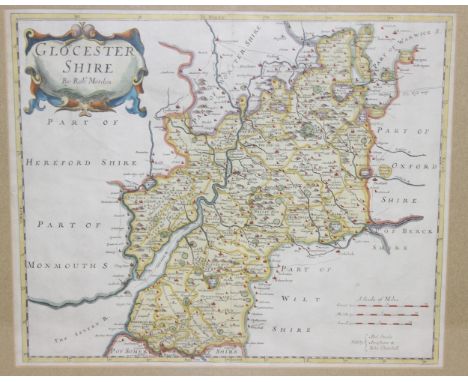
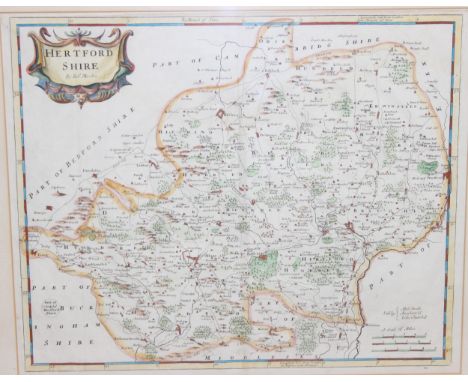
Nash (Thomas) Collections for the History of Worcestershire, London: for John White, 1799, second edition, tall folio, two volumes, rebound retaining part of original boards with attractive modern gilt calf spine with title and volume labels, fold out map, portrait frontispiece, vignette titles, various text vignettes, 81 plates and multiple fold out genealogies, scattered later added pages relating to the locations described; together with Amphlett (John) An Index to Dr Nash’s Collections for a History of Worcestershire, Oxford: James Parker for the Worcestershire Historical Society, 1894-1895, Parts I and II, large folio, original boards with pasted paper titles to front board (4)A Gloucestershire book collector
Lot 307
Quantity of antiquarian books some in need of reparation, to include "Elements of General History Ancient and Modern...." 6th Edition volume 1 only printed Cadell & W Davies 1813 with six colour folding maps published Cadell & Davies 1812 to include America, Africa, Asia, Europe, Italia and a map of the world full leather front board detached, Scotts Poetical Works, Hayden's Dictionary of Dates, Prescott "Conquest of Peru", Coote Charles "An Ecclesiastical History Ancient and Modern......" Cadell & Davies 1811, four volumes, boards missing to one volume and Bell's Cathedral Series to include Ely, Salisbury, Peterborough x 2, Winchester x 2 and many other volumes (2 boxes) Provenance: from the collection of Darrin Baines, Professor of Health Economics. Professor Baines filled his early Victorian townhouse in Leominster, Herefordshire, with Georgian and Victorian apothecary objects collected over a period of 20 years. Darrin Baines, researcher and consultant, has produced health economics and health policy projects and contributed articles to numerous academic and trade journals. Some pieces in the collection were bought from a Victorian pharmacy in Upwell, The Fens, others from pharmacists across the country, from auctions in the UK and on the continent.
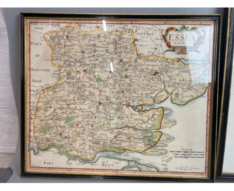
Lot 222
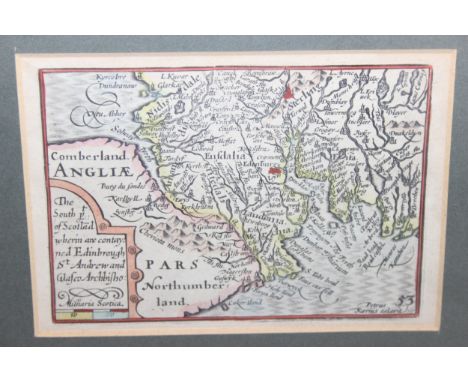
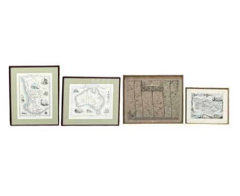
ROBERT MORDEN; a 19th century map of the County Palatine of Chester, 35 x 41cm, framed and glazed, a further modern printed map of Cheshire, after the map by J Cary, 1787, 22.5 x 27.5cm, framed and glazed, and two modern printed maps of Middlesex, a set of nine prints of 19th century plates of zodiac signs by A. Jamieson, all originally published by G & W B Whittaker, London, 1820, comprising Libra, Virgo, Aquarius, Gemini, Sagittarius, Cancer, Aries, Taurus and Pisces, all 25.5 x 30cm, all framed and glazed, fourteen modern prints of 18th century and later etchings and engravings, including a print of an engraving of George Washington, print of an engraving of the Tower of London, print of an engraving of 'Morning Dress', print of an engraving of Horse-Shoe Gall, Niagara etc,an unframed modern map of Middlesex, an unframed Louis Wain print of cats, 'Cats from France', 28 x 20cm, unframed and mounted, and an unattributed watercolour, still life of flowers, indistinctly signed lower left, 38 x 30.5cm, framed and glazed.Condition Report: Please note, the glazing on three of these pictures is cracked and broken.
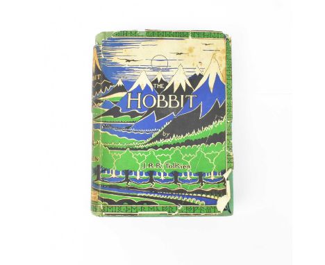
Lot 390
TOLKIEN (J.R.R.), THE HOBBIT, OR THERE AND BACK AGAIN; 1st edition, 1st impression, with ten black and white illustrations, map end papers, ‘overleaf’ and adverts at end, un-clipped d.j., Dodgson incorrectly spelt Dodgeson to the rear flap and hand-corrected by the publishers, green cloth with Smaug looking left, George Allen & Unwin Ltd, 1937, (1) Condition Report: The dust jacket is in poor condition, with foxing and is in two parts. The green cloth with some foxing spots, a lean pushing the front board over to the one side. Light fading to the top edge and fraying / rubbing to the top and bottom of the spines. The rear flap with pencil drawn runes. The front end paper with some pencil writing. Page block with foxing. Pencil name and date 1937 written in pencil to the back of the front free map page. Odd foxing spot or small mark internally. We advise you undertake your own inspection before bidding.The cataloguer has removed the dust jacket and laid it flat between clear plastic to limit any further wear during viewing.
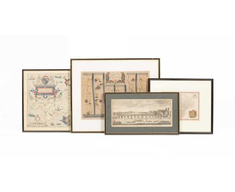
Lot 234
JOHN OGILBY; 'The Road from London to Hith in Com Kent, Including the Road by Maidstone', an 18th century engraving, 37.5 x 46.5cm, framed and glazed, a modern printed map of Australia, after the drawn and engraved map by J Rapkin, 27 x 34cm, framed and glazed, a further modern printed map of Western Australia, Swan River, 36 x 26.5cm, framed and glazed, and a small modern printed map of Kent (4).
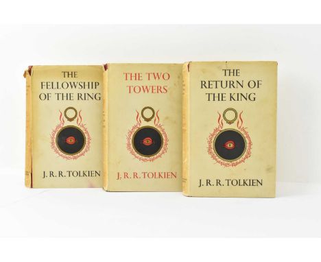
Lot 391
TOLKIEN (J.R.R.), THE LORD OF THE RINGS; 1st edition, 1st impression, THE LORD OF THE RINGS - 1954, THE TWO TOWERS - 1954, THE RETURN OF THE KING - 1955, sagging text to bottom of page 49, folding map to each volume, red cloth with gilt lettering, un-clipped d.j’s., George Allen & Unwin Ltd, (3).Condition Report: Vol 1 – Folding map detached, the glue has dried, and the map is generally ok. The jacket has split down the first fold and almost all the way down the second fold. Chips to the jacket at the top of the spine, shelf wear and some tears to the top of the jacket. Some other splits and wear throughout. Cloth with general edge rubbing and some shadowing to the top and bottom of the spine.Jacket to the Two Towers with chips and losses to the top of the spine and small tears to the bottom of the spine. Wear to the top two corners. The red cloth is brighter on this copy with some shelf wear and one shadow mark to the top of the spine.Return of the King jacket with tear and losses to the top of the spine and wear to the bottom of the spine. Tear to the top edge of jacket into the capital T. Wear to the top two corners. Red cloth with a few light marks, some shelf wear and shadow mark to the top of the spine. Map at end with a small crease to one corner.All jackets with general age wear throughout, some general marks, age toning and some foxing.The interior of all three books with some light foxing here and there, heaviest to the first volume. General toning to the pages also. Ink inscription to the front free end papers to all volumes, each one dated the year of publication.We advise customers to undertake their own inspection before bidding.
![° ° [?Gaudin, L'Abbé] - Gulistan, ou le Jardin des Roses, traduit de Saady ... engraved title device and headpiece decoration](https://cdn.globalauctionplatform.com/457d03e7-2838-480e-a3b4-b2fb009ac755/5035f8d6-c32a-4782-8189-b2fb00a73a6b/468x382.jpg)
Lot 1430
° ° [?Gaudin, L'Abbé] - Gulistan, ou le Jardin des Roses, traduit de Saady ... engraved title device and headpiece decoration; old gilt ruled calf (distressed). Paris: Chez Volland, 1791; Segur, Comte de - Histoire de Napoleon et de la Grande Armeé pendant I'année 1812 ... troisieme edition, 2 vols, 4 portraits, 2 plates and a folded map; contemp. gilt and blind decorated calf with panelled spines, ge. and marbled e/ps. Paris & Bruxelles, 1825; Gray, Thomas - The Poems of Mr. Gray To which are prefixed Memoirs of his Life and Writings by William Mason. portrait frontis., errata leaf; contemp. calf (distressed), 4to. York: printed by A. Ward ... 1775, with 3 other books (7).
Lot 884
TWO BOXES OF MISCELLANEOUS VINTAGE ITEMS, to include approximately twenty enamelled pin badges cycling related, a general post office cap badge number 101, military items map case, kit bag, leather clinometer case, and satchels, etc. loose cigarette cards a double walled ceramic pipe and cigar boxes, vintage tins, etc. (2 boxes), (sd/af)
Lot 967
F. DROZ (SWISS 19TH /20TH CENTURY) 'TEMPLE DE FENIN', a landscape with a view of the Reformed church in the village of Val-de-Ruz in Switzerland, signed and dated 1916 bottom right, oil on canvas, approximate size 23cm x 35cm, together with art related prints and ephemera, comprising an Emil Orlik lithographic print 'Am Sonntag - Bohem / On Sunday - Bohemia' depicting three women in conversation, a woodblock print depicting figures operating a threshing machine initialled MMC, a Charles L'Eplattenier lithographic print depicting a portrait of a male figure, a Henri Van Muyden lithographic print of a young child, a Ferdinand Hodler self-portrait print signed and dated 1916 in the plate, a reproduction map of Vienna dated 1649 in the plate, a Jean Cassou booklet about Raoul Dufy with colour illustrations, published by Editions D'Art Albert Skira, a similar booklet regarding Albert Marquet, Maurice Utrillo and Douanier Rousseau by Leon-Paul Fargue together with additional illustrations by Edouard Manet, Edgar Degas, Camille Pissarro, Gustave Courbet and J.B. Camille Corot
Lot 914
SEVEN BOXES OF BOOKS AND CDS, approximately one hundred titles hardback and paperback format subjects include cars, cooking, hobbies, encyclopaedia, art, etc. approximately one hundred CDs to include music such as rock, pop, easy listening, musicals, jazz etc. also included a vintage Allday's standard map of Birmingham City, a road map Pembroke and Tenby, also a map of Peak District, (7 boxes), (sd/af)
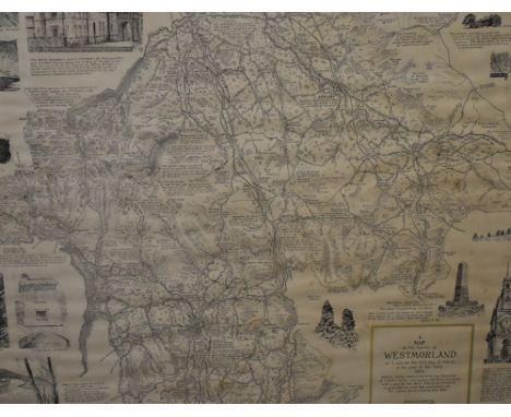
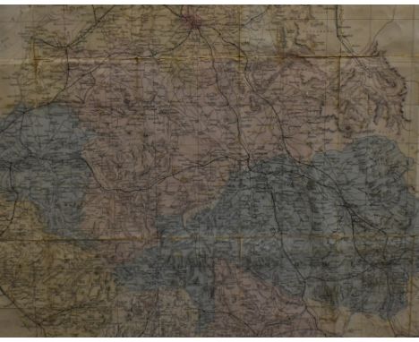
Lot 100
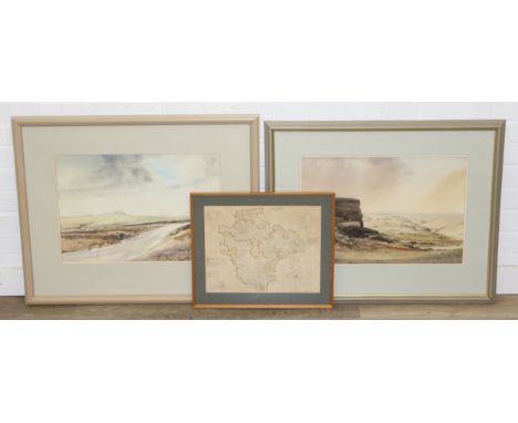
Local interest* After Alfred Wainwright (British 1907-1991) A map of the County of Westmorland, as it was on the 31st day of March in the year of our Lord 1974, commissioned by Paul N Wilson, 4th edition printed by Westmorland Gazette, Kendal, within a moulded frame, under glass 57cm x 64.5cm overall.

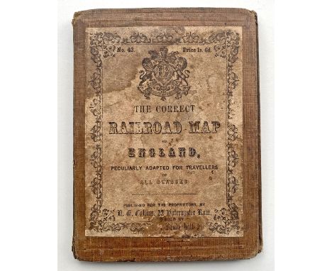
Lot 101
The Correct Railroad Map of England Peculiarly Adapted For Travellers Of All Classes circa 1849. Hardback covers open to reveal a linen fold out map 15in x 28in of the existing and unbuilt railways. As a date guide the Oxford Worcester & Wolverhampton Railway is shown as Not Yet Finished likewise the GNR.
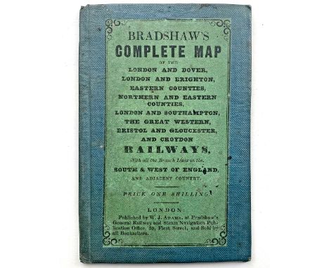
Lot 102
Bradshaw's Complete Map of the London & Dover; London & Brighton; Eastern Counties; Northern and Eastern Counties; London & Southampton; The Great Western; Bristol & Gloucester; Croydon. Circa 1842 the card cover opens to reveal a well preserved fold-out paper map measuring 12.5in x 20in. Very good condition considering the age.
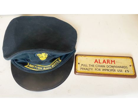
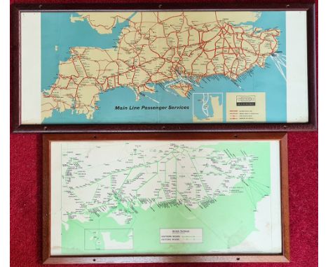
Lot 248
British Railways Porters Cap size 7.25 with sew on fishtail style badge and sew on lion holding wheel badge. Together with a wooden notice ALARM Pull Chain Penalty For Improper Use £5. Additionally an RCH Map of Scotland together with a BR(W) Map and also a map of the Southern Region. (5 items)
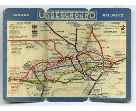
Lot 455
David Allen double fold linen and card geographic edition of the London Underground Railways circa 1912. Shows the Lines & Stations belonging to 9 different companies represented by a different colour and also London United Tramways. The Central London Railway line between Bank and Liverpool Street under construction and lines which are served by two railways use the colours of both lines. Earl's Court Exhibition Ground Shepherd's Bush Exhibition and Horticultural Hall are marked by circles Wood Lane Station has the suffix Exhibition Stn. Blue border with white title the reverse shows a blank central panel with left and right panels showing First & Last Trains. When opened it measures just short of 6in x 4.25in. A predecessor of the Beck map which wasn't introduced until 1931. Extremely uncommon and although well used it is still in fairly good condition.
-
120507 item(s)/page