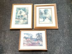
No Image Lot 815 Joanne Sibley, coloured prints, Along Marys Road and Bodden Town Grand Cayman; and another by Lois 815Joanne Sibley, coloured prints, Along Marys Road and Bodden Town Grand Cayman; and another by Lois Railtons Joanne Sibley, coloured prints, Along Marys Road and Bodden Town Grand Cayman; and another by Lois Brezinski titled West Bat Lane, each signed and... Add to watchlist Live
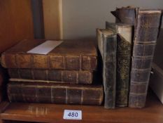
No Image Lot 480 Five 18th century books including 1796 roads of England & Wales and a 19th century book. 480Five 18th century books including 1796 roads of England & Wales and a 19th century book. Unique Auctions House Five 18th century books including 1796 roads of England & Wales and a 19th century book. Add to watchlist Live
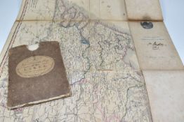
No Image Lot 826 TWO RARE ANTIQUARIAN MAPS comprising, Smith's New and Accurate Map of the Lakes in the Counties Of 826TWO RARE ANTIQUARIAN MAPS comprising, Smith's New and Accurate Map of the Lakes in the Counties Of Richard Winterton Auctioneers TWO RARE ANTIQUARIAN MAPS comprising, Smith's New and Accurate Map of the Lakes in the Counties Of Cumberland, Westmoreland And Lancaster, July 18... Add to watchlist Live
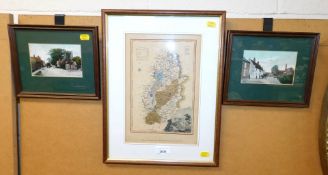
No Image Lot 2030 A hand coloured map of Nottinghamshire, 26cm x 27cm, together with two prints depicting Main Road, 2030A hand coloured map of Nottinghamshire, 26cm x 27cm, together with two prints depicting Main Road, Golding Young & Mawer A hand coloured map of Nottinghamshire, 26cm x 27cm, together with two prints depicting Main Road, Cropwell Bishop and Nottingham Road, Cropwell B... Add to watchlist Tender
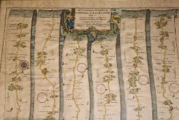
No Image Lot 266 An 18th Century hand coloured strip map of the road from Exeter to Truro by John Ogilby, 14" x 18", 266An 18th Century hand coloured strip map of the road from Exeter to Truro by John Ogilby, 14" x 18", Truro Auction Centre An 18th Century hand coloured strip map of the road from Exeter to Truro by John Ogilby, 14" x 18", framed and glazed Add to watchlist Live
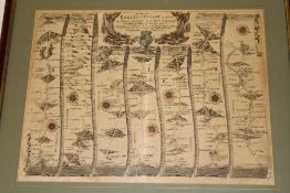
No Image Lot 267 Three 18th century hand coloured strip maps "The Continuation of the Road from London to the Lands 267Three 18th century hand coloured strip maps "The Continuation of the Road from London to the Lands Truro Auction Centre Three 18th century hand coloured strip maps "The Continuation of the Road from London to the Lands End" including plate 2 "Andover to Crookhorn"; ... Add to watchlist Live
No Image Lot 273 A late 18th - early 19th Century hand drawn map of the Roads of Revel by T. 273A late 18th - early 19th Century hand drawn map of the Roads of Revel by T. Truro Auction Centre A late 18th - early 19th Century hand drawn map of the Roads of Revel by T. Durant with manuscript text, 21½" x 16" Add to watchlist Live
No Image Lot 336 A selection of Cornish paperwork and memorabilia including North Cornwall Mission St. 336A selection of Cornish paperwork and memorabilia including North Cornwall Mission St. Truro Auction Centre A selection of Cornish paperwork and memorabilia including North Cornwall Mission St. Columb, Bazaar Souvenir Cookery Recipes, Old Cornwall in Cam... Add to watchlist Live
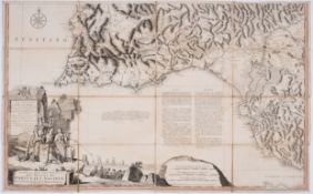
No Image Lot 133 Europe.- Portugal.- Jefferys (Thomas) Mappa ou Carta Geographica Dos Reinos de Portugale Algarve,... 133Europe.- Portugal.- Jefferys (Thomas) Mappa ou Carta Geographica Dos Reinos de Portugale Algarve,... Forum Auctions Europe.- Portugal.- Jefferys (Thomas) Mappa ou Carta Geographica Dos Reinos de Portugale Algarve, large 3 sheet map of Portugal, engraving with ou... Add to watchlist Live
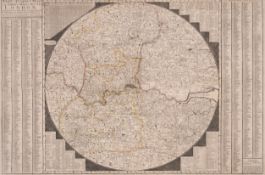
No Image Lot 377 London.- Overton (Henry) A New & Correct Map of Thirty Miles Round London Shewing all the Towns, ... 377London.- Overton (Henry) A New & Correct Map of Thirty Miles Round London Shewing all the Towns, ... Forum Auctions London.- Overton (Henry) A New & Correct Map of Thirty Miles Round London Shewing all the Towns, Villages Roads &c..., first state of this circula... Add to watchlist Live
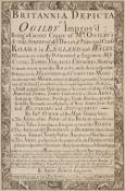
No Image Lot 31 Owen (J. & E. Bowen). Britannia Depicta...,1st edition, London: 1720 31Owen (J. & E. Bowen). Britannia Depicta...,1st edition, London: 1720 Dominic Winter Auctions Owen (John & Emanuel Bowen). Britannia Depicta or Ogilby Improv'd; being a Correct Coppy of Mr Ogilby's Actual Survey of all ye Direct & Principal... Add to watchlist Live
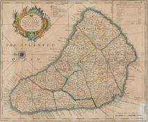
No Image Lot 85 Barbados. Bowen (Emanuel), An Accurate Map of the Island of Barbadoes..., circa 1750 85Barbados. Bowen (Emanuel), An Accurate Map of the Island of Barbadoes..., circa 1750 Dominic Winter Auctions * Barbados. Bowen (Emanuel), An Accurate Map of the Island of Barbadoes Drawn from an Actual Survey containing all the Towns, Churches, Fortificat... Add to watchlist Live
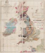
No Image Lot 88 British Isles. Knipe (James A.) Geological Map of the British Isles..., 1848 88British Isles. Knipe (James A.) Geological Map of the British Isles..., 1848 Dominic Winter Auctions British Isles. Knipe (James A.) Geological Map of the British Isles and part of France, Showing also the Inland Navigation by means of Rivers and ... Add to watchlist Live
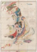
No Image Lot 100 England & Wales. Walker (J. & C.), A Geological Map..., 1837 100England & Wales. Walker (J. & C.), A Geological Map..., 1837 Dominic Winter Auctions England & Wales. Walker (J. & C.), A Geological Map of England, Wales and part of Scotland, showing also the Inland Navigation by means of Rivers ... Add to watchlist Live